Farming landscape of Vuorenmaa
Location
- Pohjoiskyläntie 1 51850 Juva Navigate
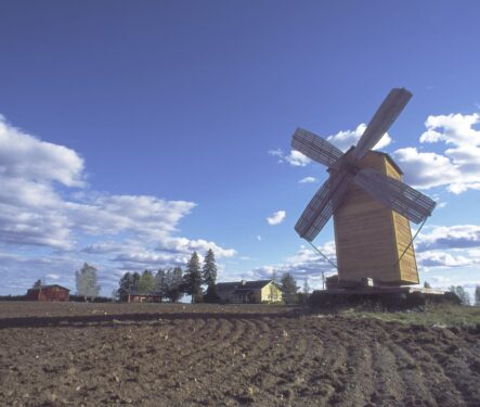
The farming landscape of Vuorenmaa is the most mountainous region in South Savo. The old village road offers fine views far to the west. The Vuorenmaa landscape area is located about 20 km northwest of the centre of Juva. As the name suggests, the landscape is rugged, even mountainous. Vuorenmaa is called the most mountainous area in South Savo. Typified by swamps and forests, Vuorenmaa's landscape is dominated by moraine plateaus, Heikinmäki and Tuhkainmäki. Farm fields have been cleared on the slopes of these two hills and the hollow between them. The old village road, the Pohjoiskyläntie, runs along the ridges and across the slopes. The ridges are surrounded by marshes, rivers and ponds, as well as the larger lakes nearby, Nevajärvi and Kangasjärvi. Vuorenmaa has a long history of settlement, having been farmed since the late 1500s. In addition to farming, Vuorenmaa has also had other economic activities: a sawmill and a mill operated from 1916 to 1960, and the village has even burned lime. Today, the area offers accommodation and horse-riding services, and the village also offers a range of services, including catering. You can admire the magnificent views from the Vuorenmaa road and the old village road that runs through the area. Along the Vuorenmaa road you can spot an old windmill in the middle of the fields. The Pohjoiskyllänti road offers a wide view across the fields to the west, towards Kangasniemi, dozens of kilometres away on the horizon. Arriving in the area The most convenient way to get to Vuorenmaa from Juva town centre by bicycle is to follow the Huitukka ridge route. By car, you can get there by turning from Pieksämäentie to Vuorenmaantie, coming from Mikkeli via Kalvitsa.